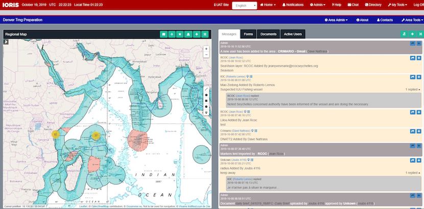
IORIS (Indian Ocean Regional Information Sharing) platform is the web-based communications tool for regional and national multi-agency use. Its primary functions are dictated by the role of the specific centre. For example, for a regional operational and coordination centre, it will provide information sharing, collaboration and coordination. For a fusion centre, it works as an information sharing and collaboration for input of information and output of enriched data. And for a Maritime Operations Centre (MOC), it can be used as an interagency command and control / crisis management platform.
Initiated by CRIMARIO for the benefit of the western Indian Ocean countries, the development has been contracted to Polymorph Ltd based in the UK who have a long history of providing e-solutions for the maritime industry, including EU NAVFOR ATALANTA Mercury platform. CRIMARIO followed a long process of collaboration with regional partners involving countries at all stages of the design and development process.
Following the successful completion of IORIS phase 1 (Nov 2017-Sept 2018), a second phase was designed based on operational and training feedback adding and refining functionality and features to further improve the platform.
Version 2.0 enriched with users’ feedback
IORIS version 2.0 has been in a testing and training phase since October 2019 and includes some exciting new key features and functionality, some of which include Voice over IP, two factor authentication security, audible / managed alerts, group private chat, EEZ overlays, simplified document feature, refined forms feature, enhanced mapping tools, improved user organization, addition of Somali & Arabic languages:
- VoIP: VoIP is a new feature that will provide an integrated voice capability between maritime centres. Initially, 50 licenses have been acquired and will be allocated to selected users at each location.
- Two factor security: The implementation of the 2-factor authentication security provides an additional level of access control to the platform. The access code is generated on the user’s personal mobile device using a free applications including Microsoft Authenticator, Google Authenticator, Authy, etc. See the training video.
- Private chat: The private chat (previously only 1 to 1) has now been enhanced to allow multiple users to communicate with a selected group within a private area. On chat creation, users select the group of people for the chat. In addition files can be added to the private chat, and also comes now with the option to encrypt the file if required.
- Audible alerts: Notification for new messages will include an audible alert to make more prominent. Email notifications will be sent to notify non-logged in users of new messages.
- EEZ overlay: The addition of global EEZ areas and borders have been added to the mapping features to complement the set of existing map layers. Layers, and/or borders can be turned on/off as required by individual users.
- Vessel intercept: A vessel intercept function to determine the optimal course and speed to intercept a vessel or target interest is now available within the mapping features. This feature is quick and easy to use and once the solution is formulated, it can be share as an ‘Alert’ within the IORIS area.
- Simplified document feature: the process of uploading documents has now been made much more user friendly. To assist with this, a set of folders are now created by default when an area is created. This provides a quick and seamless ability to upload multiple documents as soon as an area is created. The user can easily upload, encrypt, send for release, view documents, delete etc.
- Language: In addition to the current menu options for English, French & Portuguese within the IORIS platform, V2.0 will see the release of Somali & Arabic options. Languages are easily selected by default when creating a user, or it can be switched manually once logged in.
IORIS is interoperable with SeaVision the maritime situational awareness tool developed by US Navy and US Department of Transportation.
A growing number of trained and connected users
A full training package is available: user guide, training curricula, and training videos under development. As a result, a pool of trainers (15) has been set up in different locations: RCOC (Seychelles), RMIFC (Madagascar), Kenya, Mauritius, Comoros. In addition 50 US reservists have been trained to assist the participants of Cutlass Express CE19.2 exercise.
IORIS platform is operational, counting 128 users on live platform and 370 users on training platform from 5 countries (October 2019 figures) and is expected to expand to include 10 countries and regional organizations by the end of 2019..
Access to IORIS platform can be officially requested by countries and regional organisations by contacting dave.nattrass@crimario.eu.
IORIS will continue to be funded for the next few years by the EU through CRIMARIO II project expected to launch in 2020, with the transfer of ownership to the region expected by the end of the next phase.
More on IORIS: testimonies from key partners, preparation of IORIS v2.0

